


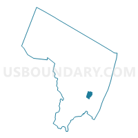
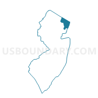
Teaneck township voting district 21, Bergen County, New Jersey
About
Outline

Summary
| Unique Area Identifier | 616770 |
| Name | Teaneck township voting district 21 |
| County | Bergen County |
| State | New Jersey |
| Area (square miles) | 1.14 |
| Land Area (square miles) | 1.02 |
| Water Area (square miles) | 0.13 |
| % of Land Area | 89.03 |
| % of Water Area | 10.97 |
| Latitude of the Internal Point | 40.87231240 |
| Longtitude of the Internal Point | -74.00550210 |
Maps

Graphs
Select a template below for downloading or customizing gragh for Teaneck township voting district 21, Bergen County, New Jersey


Neighbors
Neighoring Voting District (by Name) Neighboring Voting District on the Map
- Englewood city ward 4 voting district 3, Bergen County, NJ
- Leonia borough voting district 6, Bergen County, NJ
- Ridgefield Park village voting district 6, Bergen County, NJ
- Ridgefield Park village voting district 8, Bergen County, NJ
- Teaneck township voting district 1, Bergen County, NJ
- Teaneck township voting district 19, Bergen County, NJ
- Teaneck township voting district 2, Bergen County, NJ
- Teaneck township voting district 20, Bergen County, NJ
- Teaneck township voting district 3, Bergen County, NJ
Top 10 Neighboring County Subdivision (by Population) Neighboring County Subdivision on the Map
- Teaneck township, Bergen County, NJ (39,776)
- Englewood city, Bergen County, NJ (27,147)
- Ridgefield Park village, Bergen County, NJ (12,729)
- Leonia borough, Bergen County, NJ (8,937)
Top 10 Neighboring Place (by Population) Neighboring Place on the Map
Top 10 Neighboring Unified School District (by Population) Neighboring Unified School District on the Map
- Teaneck Township School District, NJ (39,776)
- Englewood City School District, NJ (27,147)
- Ridgefield Park Township School District, NJ (12,729)
- Leonia Borough School District, NJ (8,937)
Top 10 Neighboring State Legislative District Lower Chamber (by Population) Neighboring State Legislative District Lower Chamber on the Map
Top 10 Neighboring State Legislative District Upper Chamber (by Population) Neighboring State Legislative District Upper Chamber on the Map
Top 10 Neighboring 111th Congressional District (by Population) Neighboring 111th Congressional District on the Map
Top 10 Neighboring Census Tract (by Population) Neighboring Census Tract on the Map
- Census Tract 546, Bergen County, NJ (8,159)
- Census Tract 541, Bergen County, NJ (7,946)
- Census Tract 154, Bergen County, NJ (6,570)
- Census Tract 280.01, Bergen County, NJ (5,166)
- Census Tract 545, Bergen County, NJ (4,715)
- Census Tract 462, Bergen County, NJ (4,256)
- Census Tract 461, Bergen County, NJ (4,036)